


Emlid Flow
Description of Emlid Flow
Emlid Flow is a companion app designed for Emlid Reach receivers, specifically aimed at managing devices and facilitating various positioning tasks. This application is available for the Android platform, allowing users to efficiently handle their surveying and mapping needs. Users can download Emlid Flow to access a range of functionalities that cater to both basic and advanced surveying requirements.
The app provides full control over Emlid Reach receivers, enabling users to set up base and rover configurations, update device settings, and configure both Real-Time Kinematic (RTK) and Post-Processed Kinematic (PPK) modes. Such capabilities ensure that users can effectively manage their equipment in the field, enhancing the overall surveying experience.
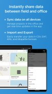
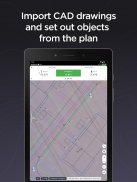
With Emlid Flow, point collection is straightforward. Users can easily stake out points, making it suitable for various applications, including ground control point collection and topographic mapping. The app supports the import and export of files in multiple formats, including CSV, DXF, KML, and Shapefile. This flexibility allows for seamless integration with other software and enhances data management capabilities.
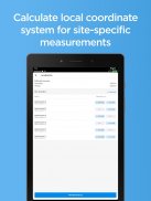
A built-in coordinate system library is a notable feature of Emlid Flow, offering access to over 1000 coordinate systems. This extensive library helps users select the appropriate system for their specific requirements. Additionally, the app allows for the creation of custom coordinate systems, providing further flexibility for specialized projects. Users can also perform base shifts, ensuring precise positioning for their tasks.
Emlid Flow includes a cloud synchronization feature with Emlid Flow 360, the associated web platform. This integration enables users to access all data from the app and manage projects without the need for manual file transfers. The synchronization process is instantaneous, allowing users to prepare and export projects efficiently, even while having the receiver on hand.
For users seeking advanced survey workflows, Emlid Flow offers a Survey Plan option that expands the app's capabilities. This plan allows for the collection and stakeout of lines and polygons, which is essential for more complex surveying tasks. The Survey Plan also includes tools for generating stakeout reports and establishing rules for accuracy control, ensuring that data collected meets necessary standards.
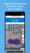
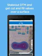
Survey codes are incorporated into Emlid Flow to help users better differentiate between various data points. This feature is particularly useful in environments where multiple data types are collected, as it aids in data organization and analysis. Additionally, the app supports Digital Terrain Model (DTM) integration, providing a more comprehensive understanding of the surveyed area.
The auto collection tool is another feature that enhances user experience by allowing for hands-free operation. This functionality is valuable in scenarios where manual data collection may be challenging or time-consuming. Furthermore, the app provides inverse and traverse tools for geometry calculations, which are essential in surveying for determining distances and angles between points.
Emlid Flow is continuously updated, ensuring that users have access to the latest features and improvements. This commitment to regular updates enhances the app's functionality and responsiveness to user needs. The app's design is focused on efficiency and usability, providing a user-friendly interface that facilitates ease of navigation and operation.
By utilizing Emlid Flow, users can streamline their surveying processes, from initial setup to data collection and project management. The combination of robust features and ease of use makes it an effective tool for professionals in the surveying and mapping industries. Whether for routine point collection or more complex surveying tasks, Emlid Flow caters to a wide range of applications.
In addition to the core functionalities, the app's ability to sync with the Emlid Flow 360 platform allows users to manage their data in a centralized manner. This feature is particularly beneficial for teams working on collaborative projects, as it ensures that all members have access to the most current data and project updates.
The comprehensive capabilities of Emlid Flow make it an essential tool for anyone involved in surveying and mapping. Its combination of device management, data collection, and project synchronization provides a complete solution for professionals seeking to enhance their workflow. Users can download Emlid Flow to improve their surveying tasks and access a range of advanced features tailored to meet their specific needs.
Emlid Flow - Version 13.6
(04-07-2025)Emlid Flow - APK Information
APK Version: 13.6Package: com.emlid.reachview3Latest Version of Emlid Flow
Other versions


 4.15
4.15


Apps in the same category

You may also like...
 4.042.654.544.134.39
 4.73
4.73


